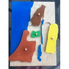
This is a custom request for a map of Israel at the Time of Jesus according to the instructions provided in the 12/22/20 e-mail communication.
Changes: larger size, keep Mediterranean Sea and land around Israel as one piece,
ORIGINAL LISTING:
*********************************************************
Regions of Israel Puzzle Map - The Holy Land at the Time of Jesus
Select from 2 core options:
- Puzzle map: please select which pieces you want to be movable
- Tracing frame: the backing piece is larger, with a frame, to accommodate that the Mediterranean Sea and the land outside of Israel are also movable pieces. Children place their paper in the frame, assemble the puzzle and trace the pieces. Please indicate which pieces you want to be movable pieces; you may also note in checkout comments which pieces you want joined.
Also select if you would like painted or unpainted.
The geography of Israel 3-part cards are a downloadable, with copyright permission to print for ONE atrium space.
Catholic Montessori, Religious Education, Catechesis of the Good Shepherd
CUSTOM REQUEST - Geography: Israel at the Time of Christ Regions Puzzle Map
-
$0.00
Available Options
Related Products
Montessori Faith Formation - Remaining Items
Additional Items of use in various placesLevel 3 Miniature Bibles: green for the Synagogue and fancy..
$0.00
Geography: Israel at the Time of Christ: Pin Maps
Unfinished wood, ready for you to finish - or painted and ready to use immediately upon arrival.&nbs..
$0.00
Geography: Israel at the Time of Christ: Topographical Relief Map
3-dimensional Map of Israel for use in homes or in atrium. Standard size: 11"x17" Larger s..
$0.00
3-Dimensional Scripture Models - Unpainted
3-D Scripture ModelsThanks to +Joshua's generous offer to help me create something new, our 3-dimens..
$0.00
Geography: Montessori Globes
Montessori globes - hand-painted - 5-6 inches wide:Land and waterContinents (painted to match the pu..
$0.00
3D Nativity Set Figures - Unpainted
3-D Scripture ModelsThanks to +Joshua's generous offer to help me create something new, our 3-dimens..
$0.00
Infancy Narrative Sets
Everything Needed to Present Each Moment in the Infancy Narratives of the Gospels3D resin figures or..
$0.00
Empty Tomb Set: Model and Figures
Wooden Empty Tomb diorama can be used as-is or painted. It can be covered in additional material to ..
$0.00
Tags: catechesis, good shepherd, Montessori faith formation, 3-6, 6-9, children of light, Level 1, Level 2, Israel at the Time of Christ, regions, bible geography, puzzle, tracing, geography



-200x200.JPG)
